
Bryce Canyon is built for changing light. At first, the amphitheatre can look like a single red wall. Then the sun reaches one fin, passes through a window and leaves the next row of hoodoos in blue shadow. Snow simplifies the same landscape into white planes and rust-coloured edges. From the rim, the formations repeat by the hundred; from a trail below it, one tower can occupy the entire sky.
The photographs are the reason to begin there. Someone searching for photos of Bryce Canyon National Park primarily wants to see the park: broad and intimate, warm and cold, from the rim and among the hoodoos. The ten landscape photographs on this page show those changes. An eleventh image, the existing editing screenshot, appears later where it can actually help.
I first explored Bryce Canyon through photographs and research rather than through field notes from a documented visit. I will not manufacture a hike or sunrise session to make the writing sound personal, and these are not my photographs. What I can offer honestly is the way I read these pictures as a photographer: how scale is created, where the colour comes from, why snow is so effective and what separates a clear record from a memorable landscape.
Bryce Canyon photos at a glance
| Photograph | Scene | What gives it character |
|---|---|---|
| Opening image | Thor’s Hammer near sunrise | One recognised hoodoo against layered warm and cool light |
| Hoodoo basin | View down into the amphitheatre | A pale trail and scattered trees establish human scale |
| Bryce Canyon in snow | Winter panorama | White snow separates the red fins and dark forest |
| Wide amphitheatre | High panoramic view at dawn | Repeating hoodoos reveal the size and density of the landscape |
| Gully between the walls | Hoodoo walls framing a descending wash | The view shifts from looking across to looking into |
| Dead-tree foreground | Broad southern landscape | Weathered wood creates depth and a strong near layer |
| Warm light on lower hoodoos | Sunlit formations beneath shadowed slopes | Colour contrast replaces the broad scenic view |
| Silent City | Dense field of hoodoos | Repetition makes the formations resemble an urban skyline |
| Wall of Windows | Riders below an eroded wall | People and animals provide unmistakable scale |
| Thor’s Hammer in daylight | Isolated hoodoo beneath a dramatic sky | Shape and caprock remain legible in stronger light |
| Editing screenshot | The winter image open in software | Demonstrates the point at which visual interpretation begins |
A closer look at the photographs
The collection moves between two scales. From the rim, Bryce Canyon becomes pattern: hundreds of fins and spires filling an amphitheatre. On the trails, pattern breaks into individual rock forms, trees and people. A complete photo essay needs both. Panorama without detail becomes decoration; detail without context makes the formations difficult to understand.
The opening image: Thor’s Hammer as a visual anchor
The hero photograph works because Thor’s Hammer is not centred in an empty frame. The hoodoo stands near the right side, catching the last or first strong light, while lower formations remain cooler and darker. The sun sits just beyond the ridge, giving the image direction without overwhelming it.
Thor’s Hammer is useful in a wide Bryce Canyon composition because it gives the eye somewhere to begin. The amphitheatre contains so many vertical forms that a photograph can become visually noisy. One recognisable hoodoo stabilises that repetition, then allows the eye to move outward through the larger landscape.
A hoodoo basin with a way through

This photograph contains a detail that many wide landscapes lack: a visible way through. The trail is not the subject — it is a thin pale line bending between the formations — but it is enough to tell the eye that a person could walk there. Trees repeat along it, small enough to show how large the rock walls are.
I like this type of scene because it does not ask colour to do all the work. The faint path creates movement, the hoodoos create rhythm and the darker conifers separate similar shades of orange. Even without a person in the frame, the photograph describes the experience of descending below the rim.
Snow turns geology into graphic contrast

Snow is unusually effective at Bryce Canyon because it does more than signal a season. It separates the landforms. White collects on horizontal surfaces; orange rock remains visible on vertical ones. The geometry of ledges, fins and bowls becomes easier to read.
The scene also exposes a common editing problem. Snow should not become neutral white everywhere. It reflects blue sky in shadow and warmer light where the sun reaches it. Removing those colour differences can make a winter photograph flat. I would protect the brightest snow, preserve cool shade and let the rock remain less saturated than it appears in memory.
The amphitheatre as a field of repeating forms

This is the broad explanatory photograph in the gallery. Hoodoos occupy most of the frame, while the plateau and distant country remain visible at the top under a pale pink sky. The repetition gives the scene scale, but the diagonal green drainage line prevents it from becoming uniform.
A panorama like this needs careful edges. Half a hoodoo cut by the frame or an unnecessary patch of bright sky can weaken the pattern. The goal is not to include everything visible from the overlook. It is to make the density legible.
Looking into the gullies between the walls

The perspective changes as soon as the camera stops looking across the amphitheatre and starts looking into it. Large formations frame a darker central valley, a gravelly wash leads away from the foreground, and the distant plateau keeps the scene from closing entirely. It is a preview of what happens on the trails, where foreground towers become taller than the horizon.
The light is flatter than in the opening photograph, but that is useful here. Strong contrast would hide detail on one canyon wall and bleach the other. A softer day records the texture and layered colour that a dramatic sunrise can sacrifice.
A dead tree creates a foreground

Bryce Canyon photographs often begin at the edge of an overlook, where the nearest hoodoos are already some distance away. The weathered trunk solves that absence of foreground. It enters from the lower edge, curves across the frame toward the canyon and creates a scale transition from wood to ridge to distant horizon.
The danger is letting the foreground become a prop. Here, the trunk belongs to the high plateau and carries the same weathering story as the rock. I would keep enough open space around it and avoid increasing clarity until every crack competes with the landscape.
Warm light isolated in the lower amphitheatre

This photograph depends on colour contrast rather than a famous formation. The lower hoodoos glow orange in direct low sunlight, while the larger slope above them sits in shade and moves toward violet and grey. The light makes a small part of the amphitheatre feel almost theatrical.
It is a reminder that the useful light is often narrow rather than general. At the start and end of the day, direct sun may reach only one band of the amphitheatre while everything around it stays cool. Waiting for that division — instead of waiting for the whole scene to be lit — is usually the stronger decision.
Silent City and the suggestion of architecture
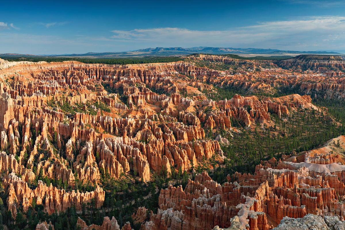
Silent City is a descriptive name rather than a geological category. From the rim, rows of hoodoos resemble towers, streets and walls. The photograph strengthens that reading by compressing the formations so that separate ridges appear stacked against one another.
Telephoto compression is valuable at Bryce Canyon because it reduces empty space between distant layers. It can turn scattered hoodoos into a dense field and isolate changing light across one section of the amphitheatre. The resulting image says less about the full geography but more about pattern.
Wall of Windows with riders below
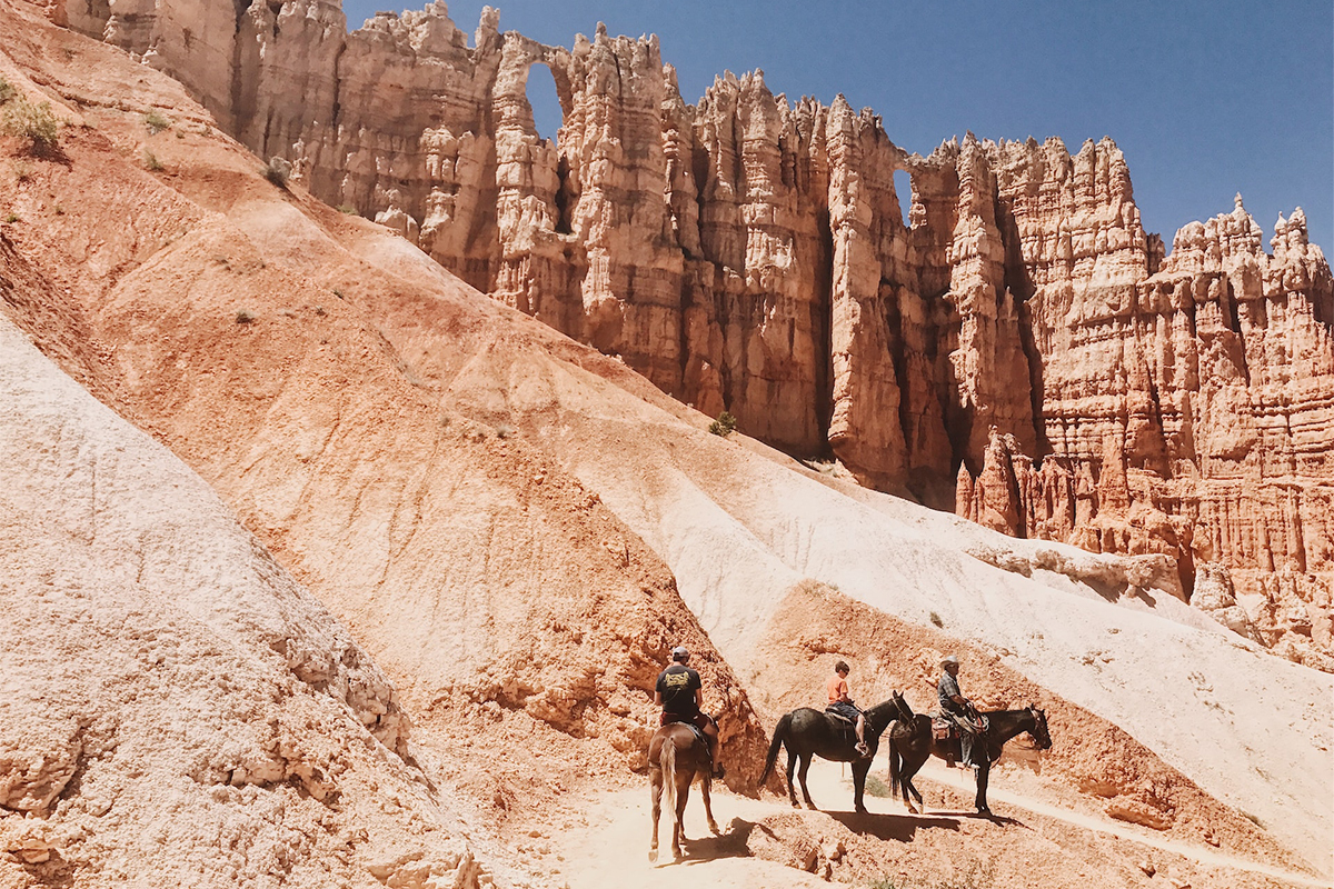
This is the most useful scale photograph in the collection, and the only one clearly made from below the rim. Without the riders, the windows might appear only a few metres tall. The three figures on the pale trail immediately correct that impression, and they give the image a narrative direction along the base of the rock.
The National Park Service calls many such openings “windows” because they are formed primarily through weathering rather than by a flowing stream. At Bryce, repeated freeze-thaw cycles widen cracks in the Claron Formation until walls become fins, fins develop openings and isolated sections become hoodoos.
Thor’s Hammer in clear daylight

The second Thor’s Hammer image answers a different question from the hero. The opening photograph is about atmosphere; this one is about shape. Stronger daylight makes the cap, narrow neck and neighbouring fins easier to understand, and the distant plateaus stay visible behind them.
Cloud gives the upper half of the frame enough structure to balance the rock. I would expose for the pale highlights in the formation and accept deeper shadows below. Recovering every dark crevice would reduce the sense of volume.
What these photos reveal about Bryce Canyon
Bryce Canyon is not technically a canyon cut by one river. It is a chain of more than a dozen horseshoe-shaped amphitheatres eroded into the eastern edge of the Paunsaugunt Plateau. The main Bryce Amphitheatre contains the largest concentration of hoodoos and the four best-known rim viewpoints: Sunrise, Sunset, Inspiration and Bryce Points.
| Detail | Fact |
|---|---|
| State | Utah, United States |
| Total area | 35,835 acres / 14,501 hectares |
| Lowest elevation | 6,620 ft / 2,018 m at Yellow Creek |
| Highest elevation | 9,115 ft / 2,778 m at Rainbow Point |
| Visitor Center elevation | 7,894 ft / 2,406 m |
| Main rock unit | Claron Formation |
| Signature landforms | Hoodoos, fins, windows, walls and fluted cliffs |
| National monument established | 1923 |
| National park designation | 1928 |
| International Dark Sky status | 2019 |
The elevation matters visually and practically. Clear air can reveal country more than 100 miles away, while winter reaches the rim earlier and lasts longer than travellers may expect from southern Utah. At roughly 8,000 feet around the amphitheatre, cold, wind and physical exertion behave differently than they do in the desert valleys below.
How hoodoos form
The old shorthand — that wind carved sandstone pillars — is not accurate enough. Bryce Canyon’s hoodoos are shaped largely from the calcium-rich sedimentary rock of the Claron Formation by frost wedging, rainwater dissolution and runoff. Wind helps carry loose material, but it is not the principal sculptor.
The process can be read as a sequence:
- Joints divide the rock into blocks.
- Water enters cracks, freezes and expands, gradually forcing the rock apart.
- Runoff and slightly acidic rain dissolve and remove weaker material.
- Broad walls narrow into fins.
- Openings develop in the fins, producing windows.
- Continued weathering separates the remaining columns into hoodoos.
The National Park Service records more than 170 freeze-thaw days in a typical year. That repeated movement explains why ice is so effective. It also explains why trails and rock openings are dynamic rather than permanent architecture.
Iron minerals contribute red, orange and brown tones through oxidation. Pale layers contain different mineral conditions and degrees of oxidation. The colours are real, but photographs easily exaggerate them; a high saturation slider can turn subtle geology into uniform orange.
Best Bryce Canyon photo spots
There is no single best viewpoint. The main overlooks explain the amphitheatre from above; trails place the camera among the hoodoos; the southern scenic drive introduces wider horizons, forest and higher elevation.
| Location | View | Best for | Main limitation |
|---|---|---|---|
| Sunrise Point | Northern Bryce Amphitheatre | Early light, wide panoramas and Queen’s Garden access | Popular at dawn; the name does not guarantee the only good sunrise angle |
| Sunset Point | Thor’s Hammer and dense hoodoos | Recognisable formations and Navajo Loop access | Crowded; the east-facing amphitheatre may not receive direct sunset light |
| Inspiration Point | High overview of the amphitheatre | Layered telephoto compositions and pattern | Exposed rim and steep edges |
| Bryce Point | Broad southern angle over the amphitheatre | Dawn light, large panoramas and long-distance layers | Parking can fill; shuttle dates are seasonal |
| Paria View | Quieter southwest-facing formations | Late light and less familiar compositions | Fewer iconic hoodoos than the main amphitheatre views |
| Fairyland Point | Northern formations and Boat Mesa | Sunrise, side light and Fairyland Loop context | Road or access can be seasonal in winter |
| Queen’s Garden Trail | Descending among hoodoos | Paths, windows, people for scale and upward angles | Return climb at altitude |
| Navajo Loop | Thor’s Hammer, Two Bridges and Wall Street area | Close formations and tight vertical compositions | Steep; not a complete loop in winter; closures can occur |
| Peekaboo Loop | Wall of Windows and inner amphitheatre | Riders, scale and deeper canyon views | Strenuous, shared with horses and mules |
| Rainbow and Yovimpa Points | Highest southern viewpoints | Long views, forest and distant plateau layers | Farther from the main amphitheatre; colder and windier |
Sunrise Point is more than its name
Sunrise Point looks across the northern amphitheatre and provides immediate access to the Rim Trail and Queen’s Garden. The broad eastern view makes dawn an obvious choice, but the National Park Service notes that the view remains strong at day’s end. The name is orientation, not a rule.
For sunrise, arrive early enough to choose a foreground before the rim brightens. A wide lens records the basin; a short telephoto isolates bands of light moving through the hoodoos. Once direct sun reaches the pale formations, highlights can become much brighter than the shadowed floor.
Sunset Point and Thor’s Hammer
Sunset Point gives the clearest relationship to Thor’s Hammer and the Navajo Loop. Despite the name, much of the amphitheatre faces east, so the most dramatic direct light may occur in the morning. Sunset can still produce a coloured sky, soft reflected light and blue-hour contrast.
The strongest composition is not necessarily the tightest one. Leave enough surrounding formations for Thor’s Hammer to have context. In a telephoto frame, watch for bright rock edges touching the cap and weakening its silhouette.
Inspiration Point and Bryce Point
Inspiration Point looks down across a dense hoodoo field and suits long-lens studies of repetition. Bryce Point provides a larger sweep and is particularly effective when dawn reaches successive layers. Both are exposed positions where wind can affect a tripod and cold can reduce battery performance.
From a high overlook, the horizon is easy to forget. A small tilt may be difficult to see among diagonal ridges but becomes obvious in the distant plateau. I would level against the far landscape, then allow the hoodoo lines to retain their natural slope.
Below the rim
The photographs change most dramatically below the rim. Queen’s Garden is the least difficult trail descending into the canyon, while the Queen’s/Navajo combination forms a popular 2.9-mile route between Sunrise and Sunset Points. Peekaboo Loop reaches the Wall of Windows and runs through the heart of the amphitheatre.
The descent can make a route feel easier than it is. Every metre lost must be regained at elevations around 8,000 feet. Camera equipment, heat and stops for photographs extend the time. Current trail conditions matter after snow, rain or rockfall; check the official conditions page before relying on a saved itinerary.
Light, colour and weather
Bryce Canyon is often presented as a sunrise-only landscape. Morning is excellent, but the photographs show several other possibilities: soft overcast detail, snow, clear daylight and warm light isolated in a small section of the amphitheatre.
A practical light guide
| Time or condition | Visual effect | Best use |
|---|---|---|
| Pre-dawn blue hour | Cool rock and quiet tonal separation | Silhouettes, subtle colour and low-crowd rim views |
| Sunrise | Strong side light and warm upper hoodoos | Bryce Point, Sunrise Point and broad amphitheatre layers |
| Mid-morning | Clear detail and increasing colour contrast | Trail photography, geology and telephoto patterns |
| Midday | Hard light, deep slots and bright sky | Graphic shadows, windows and controlled black-and-white work |
| Late afternoon | Softer reflected light and possible cloud colour | Paria View, forest foregrounds and quieter scenes |
| Sunset and dusk | Coloured sky followed by cool canyon shade | Blue-hour landscapes and balanced long exposures |
| Snow | Red-white contrast and simplified form | Panoramas, isolated hoodoos and minimal compositions |
| Storm light | Moving sun patches and dramatic atmosphere | Telephoto details — but only from a safe position |
Summer storms require more than aesthetic interest. Lightning is especially dangerous along exposed rims in July and August, and heavy rain can trigger flash flooding below. If thunder is audible, the photograph is no longer the priority. Move away from exposed overlooks and follow current safety guidance.
The existing Instagram view
The embedded post is useful here because social platforms are one of the main ways Bryce Canyon’s colour becomes exaggerated and repeated. A compelling image does not need every orange channel pushed to its limit. Specific light, weather and viewpoint tell a stronger story than generic saturation.
When sharing a photograph, I would identify the viewpoint or trail if doing so does not direct people off route, and I would avoid geotagging unofficial shortcuts. Bryce’s formations are fragile, and repeated footsteps outside established surfaces have a larger effect than one post suggests.
Camera and phone guidance
Bryce Canyon rewards both wide and long focal lengths. The scene is large, but the most distinctive images often isolate a small group of hoodoos rather than attempting to fit the entire amphitheatre into one frame.
Lens choice by scene
| Scene | Useful full-frame starting range | What it does |
|---|---|---|
| Broad amphitheatre from the rim | 16–35 mm | Includes foreground, hoodoo basin and distant plateau |
| Natural-looking overlook view | 35–70 mm | Preserves scale without extreme wide-angle stretching |
| Pattern and isolated hoodoos | 70–200 mm | Compresses layers and excludes empty sky |
| Distant details and moving light | 200–400 mm | Selects small formations within the amphitheatre |
| Trail below the rim | 20–50 mm | Balances nearby walls, people and open sky |
| Night sky | 14–24 mm with a bright aperture | Includes stars and a recognisable foreground silhouette |
| Phone | Main camera for wide scenes; optical telephoto for pattern | Avoids the artificial detail of maximum digital zoom |
A polarising filter can deepen blue sky and reduce glare, but it needs restraint. On an ultra-wide lens, polarisation varies across the sky and can create a dark uneven band. It can also remove useful reflected light from rock. Rotate it while watching the complete frame rather than assuming maximum effect is best.
Exposure starting points
| Situation | Starting point | Priority |
|---|---|---|
| Sunrise on a tripod | ISO 100, f/8–f/11, bracketed shutter times | Dynamic range between lit hoodoos and shadow |
| Daylight panorama | ISO 100, f/8, 1/250 sec or faster | Sharp rock and protected highlights |
| Telephoto hoodoo detail | ISO 100–400, f/5.6–f/8, 1/500 sec or faster | Control wind and focal-length shake |
| Trail photography handheld | ISO 100–800, f/5.6–f/8, 1/250 sec or faster | Sharp people, animals and foreground rock |
| Blue hour | ISO 100–400 on a tripod, f/5.6–f/8 | Clean colour and sufficient depth of field |
| Snow | Add exposure only after checking highlights; bracket if needed | White snow without clipping |
| Stars and hoodoo silhouette | ISO 1600–6400, bright aperture, 10–20 sec | Stars before rotation becomes obvious |
These are starting points, not universal settings. Wind, focal length, stabilisation and intended movement matter more than copying one exposure. A sharp high-ISO frame is preferable to a clean file blurred by a shutter speed that was too slow.
Composition in a crowded landscape
The amphitheatre contains more visual information than a frame can organise. I would begin with one structural choice:
- one named hoodoo as an anchor;
- a path as a leading line;
- repeating formations compressed by a telephoto lens;
- a tree, snowbank or rim as foreground;
- a person or rider for scale;
- or open sky as deliberate negative space.
Trying to use all six at once usually produces confusion. Check the frame edges for clipped towers and bright patches. At sunrise, wait for light to reach a coherent group of formations rather than chasing every illuminated point.
Phone photography
The phone’s main camera handles rim panoramas well, particularly when there is a foreground. Use an optical telephoto camera for isolated hoodoos. Avoid maximum digital zoom, which can invent detail in the textured rock and make the formations look painted.
At sunrise or in snow, tap the brightest hoodoo and lower exposure slightly. Use RAW capture if the phone offers it, but do not assume RAW can recover a clipped sky. For blue hour, brace the phone against a railing only without obstructing others, use a timer and review the image at full size before the light disappears.
Night photography and dark skies
Bryce Canyon became an International Dark Sky Park in 2019. Its elevation, dry air and distance from large cities make the Milky Way and thousands of stars visible on a clear, moonless night. The park remains open 24 hours, which gives night photographers legal access to public areas unless a specific closure or condition says otherwise.
Night photography requires a different kind of care. Temperatures fall quickly at elevation, familiar rim paths become difficult to judge and headlights can ruin both dark adaptation and another photographer’s exposure. Use a red light when practical, remain on established surfaces and never back toward an edge while looking through the camera.
For a starscape, expose the sky and allow the hoodoos to become a silhouette, or make a separate low-light foreground exposure without introducing artificial light that disturbs visitors or wildlife. Moonlight can reveal the formations, but it reduces Milky Way contrast. Neither approach is universally better.
Editing Bryce Canyon photographs
Bryce Canyon is easy to over-edit because the raw ingredients already look dramatic: orange rock, deep blue sky, white snow and dark conifers. Increasing every colour produces impact at thumbnail size but destroys the quieter differences between layers.

My restrained sequence would be:
- correct lens distortion and chromatic aberration;
- set white balance from a neutral rock or snow reference, then adjust by eye;
- recover bright snow and sunlit hoodoos before lifting deep canyon shadow;
- use modest local contrast to separate overlapping fins;
- control orange and blue channels independently rather than increasing global saturation;
- sharpen for the final output size, not at maximum magnification;
- check for halos along the rim and unnatural dark bands in the sky.
Snow should retain cool reflected light, and shaded rock should not become black merely to make sunlit hoodoos brighter. If the file needs extreme dehaze to feel deep, the original scene may simply have contained atmospheric haze. That is part of the landscape, not always a defect.
For a free workflow, my guide to editing photos in GIMP covers the basic tools without requiring a subscription.
Bryce Canyon map and location
Bryce Canyon National Park is in south-central Utah, east of Interstate 15 and reached from Utah State Route 12 via Highway 63. The main amphitheatre viewpoints occupy the first three miles of the park road. The southern scenic drive continues to Rainbow and Yovimpa Points near mile 18.
The map makes the park look compact, but elevation and slow scenic stops stretch driving time. The amphitheatre, southern viewpoints and trail photography are better treated as separate blocks than as a checklist to finish in one rushed circuit.
Planning a Bryce Canyon visit in 2026
Bryce Canyon is open 24 hours a day throughout the year, and no advance reservation is required for ordinary entry. Visitor-centre hours, shuttle service, trail access and the southern scenic drive can still vary by season and conditions.
Entrance fees, including the 2026 nonresident charge
When this article was updated on 13 August 2026, the official cashless fees were:
| Entry type | Standard seven-day fee |
|---|---|
| Private non-commercial vehicle and occupants | $35 |
| Motorcycle | $30 |
| Individual entering on foot or bicycle, age 16+ | $20 |
| Bryce Canyon annual pass | $70, listed for US citizens and residents |
| America the Beautiful annual pass | $80 resident / $250 nonresident |
The 2026 National Park Service policy also required each non-US resident aged 16 or older to pay an additional $100 nonresident fee on top of the standard entrance fee unless admitted with an eligible annual pass or America the Beautiful Pass. This applied even to people entering with commercial tours.
That policy is unusually consequential for international families and can change. Confirm it on the official fees page immediately before booking or travel rather than relying on an older article or screenshot.
The 2026 shuttle
The park shuttle is not mandatory, but it is the easiest way to avoid full parking lots around the main amphitheatre. It is free with proof of park admission, typically runs about every 15 minutes and serves Bryce, Inspiration, Sunset and Sunrise Points as well as trailheads and facilities.
| 2026 dates | Operating hours |
|---|---|
| April 3 – May 8 | 8 a.m. – 6 p.m. |
| May 9 – September 20 | 8 a.m. – 8 p.m. |
| September 21 – October 18 | 8 a.m. – 6 p.m. |
Buses are wheelchair accessible and carry up to two bicycles on front racks. Pets are not allowed. The recommended places to park and board are the Shuttle Station in Bryce Canyon City or the additional lot opposite the Visitor Center. Private vehicles remain permitted, but viewpoint spaces can fill during peak periods.
Trail choices for photographers
| Trail | Distance | Elevation change | Photographic strength |
|---|---|---|---|
| Rim Trail, Sunrise–Sunset section | 0.5 mi / 0.8 km one way | Minimal | Accessible panorama and changing rim angles |
| Queen’s Garden | 1.8 mi / 2.9 km | 450 ft / 137 m | Least difficult descent among hoodoos |
| Navajo Loop | 1.3 mi / 2.2 km | 515 ft / 157 m | Thor’s Hammer, Two Bridges and Wall Street area |
| Queen’s/Navajo combination | 2.9 mi / 4.6 km | 625 ft / 191 m | Best compact transition from rim to hoodoo floor |
| Peekaboo Loop | 5.5 mi / 8.8 km | 1,560 ft / 474 m | Wall of Windows, riders and inner amphitheatre |
| Fairyland Loop | 8.0 mi / 12.9 km | 1,900 ft / 579 m | Longer, quieter sequence of walls and hoodoos |
Distances do not express the full effort. The return climb occurs at high elevation, and even moderate exertion can feel harder. Carry water, use footwear with real traction and allow additional time for stopping safely with a camera. On shared horse trails, stand to the side when instructed and protect equipment from dust.
Accessibility
Most viewpoint car parks provide accessible spaces and ramps. The paved half-mile Rim Trail section between Sunset and Sunrise Points is wheelchair accessible and also practical with a stroller. Elevations from 8,000 to 9,100 feet can still cause fatigue, and assistance may be useful on sloping overlook approaches.
Rainbow Point has a paved viewpoint route with gentle grades. The one-mile Bristlecone Loop has a hard surface but includes grades that do not meet accessibility standards, so it may require assistance. Check the detailed official accessibility guide against individual needs.
Weather and safety
Bryce Canyon’s high elevation produces cold nights in every season. Average July highs are around 80°F / 27°C, but winter daytime averages remain near freezing and record lows are severe. Snow can arrive early and remain late.
Summer monsoon storms create lightning risk on the rim and flash-flood risk below it. Winter introduces ice, deep snow and seasonal trail or road closures. Before dawn or night photography, check the forecast, current alerts and actual road surface rather than treating a clear sky in a nearby lower town as evidence of rim conditions.
Photography permits and drones
Current National Park Service rules generally allow filming and still photography without a permit when the activity involves eight or fewer people, occurs in areas open to the public, uses hand-carried equipment, requires no exclusive use, does not harm resources or interfere with visitors and creates no extra administrative cost.
Larger or more disruptive productions may require a permit. Commercial and non-commercial status does not by itself decide the issue under the current rule. Drones and other remote-controlled aircraft are prohibited within Bryce Canyon National Park.
A realistic photography plan
If I had only half a day
I would concentrate on one light transition and one short walking sequence rather than drive to every overlook. At dawn, that could mean Bryce Point or Sunrise Point, followed by the Rim Trail to Sunset Point and a short descent only if conditions and fitness allow. In the afternoon, it could mean Inspiration Point, Paria View and blue hour near the main amphitheatre.
If I had a full day
The strongest full-day structure is rim, trail and distance:
- photograph dawn from a main amphitheatre viewpoint;
- descend Queen’s Garden and return via the open side of Navajo Loop;
- rest and back up files during hard midday light;
- use the shuttle or drive to Inspiration and Bryce Points;
- continue south only if time and conditions make Rainbow Point realistic;
- finish with dusk or a planned night-sky session.
This is a photographic sequence, not a claim of personal completion. Its value is that each block produces a genuinely different image instead of eleven versions of the same overlook.
Frequently asked questions
Where can I see the best photos of Bryce Canyon National Park?
This page contains ten Bryce Canyon landscape photographs and one existing editing example. The gallery includes Thor’s Hammer, snowy hoodoos, Silent City, Wall of Windows, wide amphitheatre views, canyon gullies and changing light.
What is the best viewpoint for Bryce Canyon photos?
Bryce Point is strongest for a broad dawn panorama, Inspiration Point for dense hoodoo patterns, Sunset Point for Thor’s Hammer and Sunrise Point for Queen’s Garden access and northern amphitheatre views. The best choice depends on whether the photograph needs scale, pattern or one named formation.
Is sunrise or sunset better at Bryce Canyon?
Sunrise often gives stronger direct light because the main amphitheatre faces east. Sunset can still produce a coloured sky, reflected light and excellent blue-hour photographs. The point names do not guarantee that one is useful only at the time in its name.
What is a hoodoo?
A hoodoo is a tall, irregular rock spire left as walls and fins are weathered and eroded. At Bryce Canyon, frost wedging, dissolving rainwater and runoff act on the Claron Formation. Wind is a secondary transport process, not the main carving force.
Is Bryce Canyon really a canyon?
Not in the usual river-cut sense. It is a series of horseshoe-shaped amphitheatres eroded into the edge of the Paunsaugunt Plateau.
Can I photograph Thor’s Hammer from the rim?
Yes. Sunset Point provides the familiar elevated view, while the Navajo Loop area offers closer perspectives when the relevant route is open. Morning and daylight produce different relationships between the caprock, column and background.
Is Bryce Canyon open at night?
Yes. The park is open 24 hours year-round unless a specific closure applies. It has International Dark Sky status and is excellent for stars, but night visitors must account for cold, darkness, edges, wildlife and other people’s dark adaptation.
Do I need a reservation in 2026?
No advance reservation is required for ordinary park entry. Lodging and campsites have separate reservation systems and can fill.
How much does Bryce Canyon cost in 2026?
When checked in August 2026, a seven-day private-vehicle pass cost $35. Non-US residents aged 16 or older also faced a $100 per-person surcharge unless admitted with an eligible annual pass or America the Beautiful Pass. Recheck the official fees page because this policy can change.
Is the shuttle free?
The seasonal shuttle is included with proof of park admission. It ran from April 3 through October 18 in 2026, with longer hours during summer. It is optional but useful when amphitheatre car parks are full.
Can I use a tripod?
Normal small-scale photography using qualifying hand-carried equipment generally does not require a permit when all NPS conditions are met. Do not block paths or overlooks, and check current rules before an organised or equipment-heavy production.
Can I fly a drone?
No. Remote-controlled aircraft, including drones, are prohibited inside Bryce Canyon National Park.
Is Bryce Canyon accessible without hiking below the rim?
Yes. The principal experience begins at rim viewpoints, many of which have accessible parking and paved approaches. The half-mile Rim Trail section between Sunset and Sunrise Points is wheelchair accessible and provides continuous amphitheatre views.
What other photo-led park guides can I read?
Continue with my photos of Petrified Forest National Park, photos of Acadia National Park and photos of Mount Rushmore collections. Each begins with the photographs before expanding into locations and practical planning.
Final thoughts
The strongest photos of Bryce Canyon National Park do not all depend on the widest view or the reddest rock. One needs Thor’s Hammer to hold the frame together. Another needs a trail, tree or rider to reveal scale. Snow makes the landforms clearer; a narrow band of low sun makes the colour less literal; a telephoto lens turns a vast amphitheatre into rhythm.
Bryce Canyon is frequently described as otherworldly, but that word can become a substitute for looking. The photographs are more interesting when they remain specific: ice widening a crack, a window cut through a fin, a dark conifer against pale rock, or one strip of sun moving across Silent City. Those details are not smaller than the panorama. They are what make the panorama understandable.