
Granite summits above the Atlantic, still water beneath the Bubbles, spruce forest, weathered rock and one of Maine’s most recognizable lighthouses: this is Acadia in photographs.
Acadia National Park does not reveal itself in one grand view. Its character is built from contrasts: mountain and ocean, bare pink granite and deep green forest, sheltered ponds and an exposed shoreline that can change temperament in minutes.
That is why I have kept this page photo-led. If you came looking for photos of Acadia National Park, the photographs should come first—not after a long history lesson, a packing list or a collection of generic travel tips. The eight images below move from the open summit of Cadillac Mountain to Jordan Pond, the forest interior and the Atlantic edge of Mount Desert Island.
After the gallery, I have added the context that makes the pictures more useful: what each landscape shows, where to find Acadia’s most photogenic places, how the light changes through the year and what visitors need to know about reservations, tides and park rules in 2026.
Acadia National Park in eight photographs
1. Sunrise over the islands from Cadillac Mountain

Sunrise opens over Frenchman Bay from the exposed granite of Cadillac Mountain.
The first image carries several of Acadia’s defining elements at once: a high granite foreground, low islands scattered across Frenchman Bay and a horizon that seems to begin in the Atlantic. Before the sun clears the horizon, the scene is made from restrained colors—blue water, muted rock and a warm band of light. A few minutes later, everything becomes brighter and less delicate.
Cadillac Mountain rises 1,530 feet above sea level. It is not a vast alpine summit, but its position beside the ocean makes it feel much higher. From here, the geography of Mount Desert Island becomes legible: mountain ridges, bays, forest and islands are compressed into a single view.
Sunrise is also Cadillac Mountain’s busiest hour. One often-repeated claim needs a qualification: it is the first place in the United States to see sunrise only from roughly October 7 through March 6, not throughout the year. The National Park Service recommends arriving about an hour before sunrise or sunset, both for the changing light and because the summit is extremely popular.
2. Cadillac Mountain after first light

Low morning light reaches across Cadillac Mountain after the sun has cleared the horizon.
The second Cadillac photograph is quieter than the first. Instead of making the sunrise itself the subject, it shows what early light does to the summit: rock catches warmth, shadows stretch across the foreground and the distant water remains comparatively cool.
This is often the more interesting moment photographically. The instant of sunrise draws everyone toward the same horizon, but the light immediately afterward begins to describe the landscape in three dimensions. I would rather turn around and watch where that light falls than make fifty nearly identical frames of the sun.
Cadillac’s weather can be very different from conditions near sea level. Fog may erase the horizon; wind can make a summer morning feel cold; wet granite becomes slippery. Those changes are not necessarily bad for photographs. A clear sunrise gives scale and color, while fog removes distance and leaves a more restrained picture of rock, spruce and weather.
3. Jordan Pond and the Bubbles

North Bubble and South Bubble rise beyond the clear water of Jordan Pond.
Jordan Pond is one of Acadia’s most recognizable compositions. The long pond narrows toward two rounded mountains—North Bubble and South Bubble—creating a view that almost arranges itself. Shoreline vegetation provides a foreground, the water opens the middle of the frame and the Bubbles close the distance.
What makes this image work is not spectacle but order. The scene has layers, a strong central direction and enough calm water to echo the sky. On a still morning, the reflection can become almost symmetrical. With wind, the surface breaks into texture and the photograph feels less formal.
The pond is a protected public water supply, and swimming is not permitted. Visitors should remain on designated paths, particularly around fragile shoreline vegetation. The Jordan Pond area is served by the fare-free Island Explorer in season, which can be a far better option than circling a full parking area.
4. A quieter view across Jordan Pond
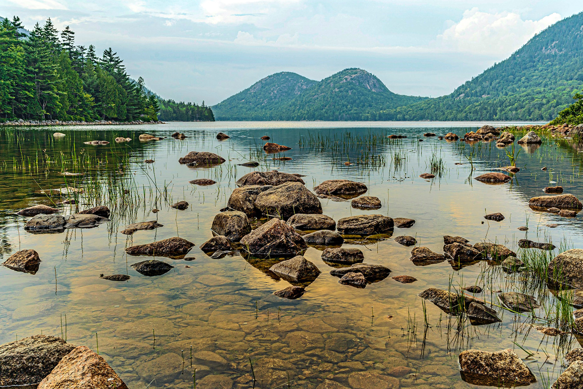
Another side of Jordan Pond, with the Bubbles held low beneath an open sky.
The original version of this article placed this photograph under a history heading. It belongs here instead, beside the other Jordan Pond image. A photograph should be identified by what it actually shows, not used as decoration for an unrelated paragraph.
Compared with the previous frame, this view gives more room to the sky and shoreline. The Bubbles are present but do not dominate. It is a useful reminder that a famous place does not have only one composition. A few steps to either side, a lower camera position or a change from horizontal to vertical can shift the balance completely.
At Jordan Pond, I would look for natural edges rather than force the mountains into the exact center every time: an opening between shrubs, a curve in the shoreline, a patch of reeds or a dark foreground rock. These elements make the image feel observed rather than copied from a postcard.
5. Granite and surf along Acadia’s Ocean Drive
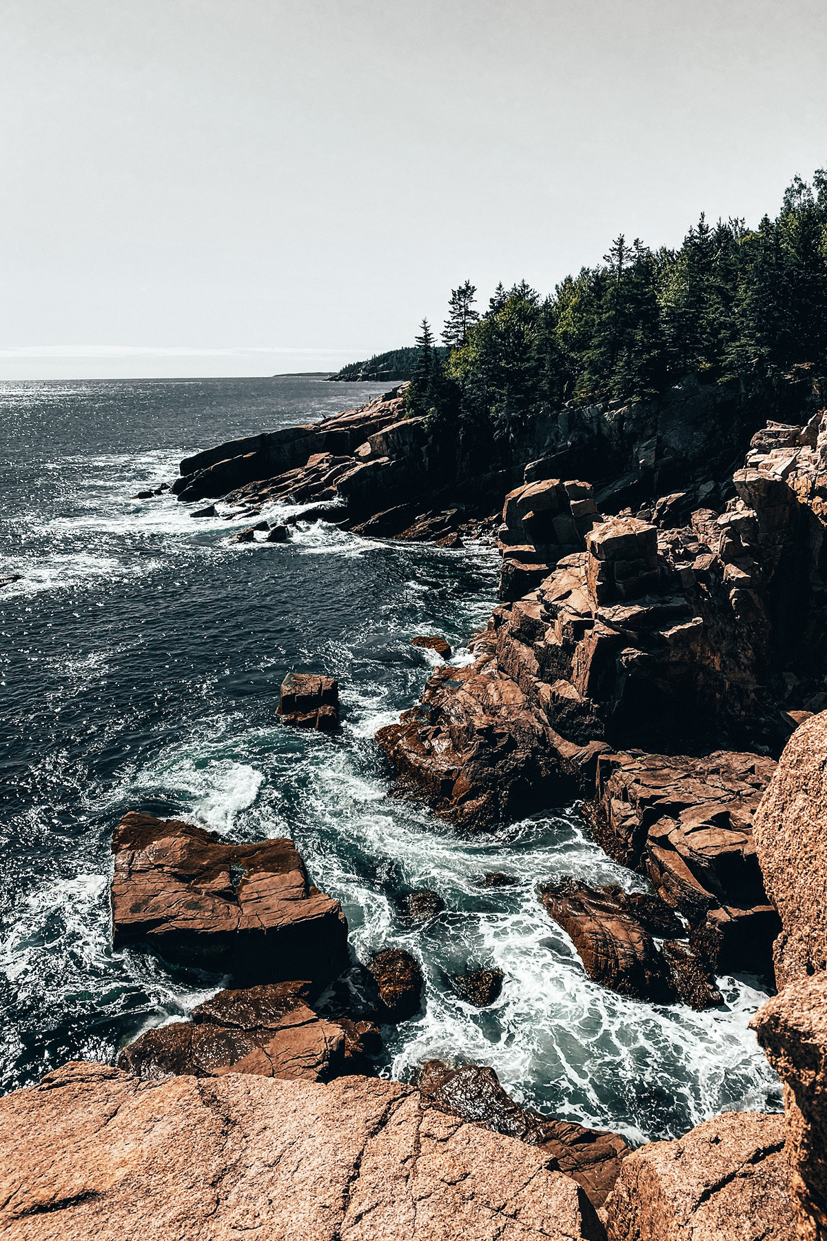
The Atlantic meets Acadia’s fractured granite coast along Ocean Drive.
This vertical photograph is about the collision between water and rock. The diagonal shoreline pulls the eye through the frame; white water separates the darker ocean from the warm-toned granite. It shows the essential character of Acadia’s eastern coast even though the narrow inlet of Thunder Hole itself is not visible.
That distinction matters. The previous article labeled the image “Thunder Hole,” but a caption should not promise a landmark the photograph does not clearly show. A more honest description is the rocky coast along Ocean Drive, the popular stretch between Sand Beach and Otter Point that includes Thunder Hole and Otter Cliff.
The sea here is never just background. Acadia experiences an eight- to twelve-foot tidal rise and fall twice each day, according to the National Park Service’s guide to tides. Swell, wind and approaching storms can send water much farther onto the rocks than expected. No photograph is worth moving past a railing or standing on wet granite at the edge.
6. A boardwalk through the forest

A wooden path disappears into Acadia’s shaded forest.
Acadia is often reduced to sunrise, lighthouses and crashing waves, yet much of the park is an intimate landscape of spruce, fir, moss, fern and wet ground. This boardwalk image changes the pace of the gallery. There is no horizon and no famous landmark—only a path, soft light and the suggestion of what lies beyond the next turn.
Overcast weather is especially effective in the woods. Direct sun tends to break a forest into bright patches and black shadows; cloud cover lowers the contrast and lets greens, bark and small textures remain visible. After rain, the color becomes deeper, though wooden surfaces, roots and rocks can be slick.
The exact trail shown in this legacy image is not confirmed, so I would not attach a specific trail name without checking the original file or location record. The image still earns its place because it shows an important side of Acadia that the iconic overlooks cannot: the experience of moving slowly through the park rather than looking out across it.
7. Bass Harbor Head Light above the Atlantic

Bass Harbor Head Light Station stands above the southwest coast of Mount Desert Island.
The white tower and red lantern of Bass Harbor Head Light create one of Acadia’s clearest visual anchors. Rock fills the lower frame, evergreens hold the opposite edge and the lighthouse sits between land and open water. It is both architecture and landscape, small enough to reveal the scale of the coast around it.
The light station was built in 1858 and still marks the entrance to Bass Harbor and Blue Hill Bay. Visitors can see the exterior from a paved walkway or follow a short boardwalk and stairs to the familiar shoreline viewpoint; the interior is not open to the public.
Its popularity is the practical complication. The National Park Service warns of a very small parking lot and sunset congestion. Roadside parking is prohibited, buses and RVs cannot use the narrow access road, and there is no public transit to the site. A photograph that looks solitary may have been made beside a dense line of tripods, so flexibility matters more here than any particular camera setting.
8. First light on the Atlantic edge

Color gathers above the Atlantic while the granite shore remains in shadow.
The final photograph returns to the coast at the edge of day. Its vertical shape divides the scene into three simple bands: dark foreground rock, moving ocean and a warm sky. The light is present, but the sun is not. That restraint gives the picture more atmosphere than a bright solar disk would.
I often find this interval more expressive than sunrise itself. Before dawn, exposures are long enough to soften moving water, colors are subtle and the landscape has not yet separated into harsh highlights and shadows. After sunset, the sequence happens in reverse. In either direction, the best color may arrive twenty or thirty minutes away from the official sunrise or sunset time.
The precise viewpoint of this older image is not documented. Rather than invent a location, I treat it as what it visibly is: a study of Acadia’s rocky Atlantic shoreline at first or last light. That is enough. Good captions add useful truth; they do not need to manufacture certainty.
What these Acadia photographs show
The eight photographs are not a complete inventory of the park, but together they explain its visual rhythm. Two images show the summit, two the pond, two the coast, one the forest and one the lighthouse. The repetition is useful: Acadia’s identity comes not from a single attraction but from the way these environments sit unusually close together.
| Photograph | Main subject | Part of the park | What gives the image its character |
|---|---|---|---|
| Cadillac sunrise | Island-dotted coastal panorama | Cadillac Mountain, Mount Desert Island | Warm horizon, cool water and high granite foreground |
| Cadillac after sunrise | Summit rock and morning light | Cadillac Mountain | Long shadows and low, directional light |
| Jordan Pond and the Bubbles | Pond, shoreline and twin mountains | Jordan Pond | Layered composition and possible reflections |
| Wide Jordan Pond view | Open water and distant mountains | Jordan Pond | Negative space and a quieter sense of scale |
| Granite and surf | Atlantic shoreline | Ocean Drive area | Diagonal rock, white water and movement |
| Forest boardwalk | Trail through dense woodland | Exact trail unconfirmed | Soft light, repetition and a strong leading line |
| Bass Harbor Head Light | Lighthouse above granite coast | Southwest Mount Desert Island | Human scale against rock, trees and sea |
| Coast at first light | Rocky shore and colored sky | Exact viewpoint unconfirmed | Long exposure mood and simple tonal layers |
If two additional images are added later, I would not choose more views of Cadillac or Jordan Pond. The gallery would become more complete with Sand Beach beneath Great Head and either a stone bridge on the carriage roads or the open granite at Schoodic Point. Those photographs would add forms that the present set does not yet contain.
Where is Acadia National Park?
Acadia lies on the coast of Maine, principally on Mount Desert Island, with additional parkland on the Schoodic Peninsula, Isle au Haut and smaller coastal islands. Bar Harbor is the best-known gateway town, but it is not the whole park.
The landscape is compact enough that a visitor can move from mountain summit to ocean shore and freshwater pond in a single day. The 27-mile Park Loop Road connects many of the most familiar places on the eastern side of Mount Desert Island, including Sand Beach, Thunder Hole, Otter Point, Jordan Pond and Cadillac Mountain. Beyond the road are 158 miles of hiking trails and 45 miles of historic carriage roads, according to the National Park Service’s current park overview.
That concentration is one reason Acadia photographs so well. The scenery changes quickly without requiring the vast driving distances common in western national parks. It is also why the most famous areas become congested: many visitors are trying to reach the same few overlooks at the same hours.
The best places for more Acadia National Park pictures
The gallery above is the center of this article, but it does not exhaust the park. These are the locations I would prioritize when building a broader visual story of Acadia—not merely a checklist of its most recognizable postcards.
Cadillac Mountain
Cadillac provides the widest view in the park: Frenchman Bay, the Porcupine Islands, rounded ridges and the Atlantic horizon. Sunrise is famous, but it is not automatically the best light every morning. Fog can hide the view entirely, while afternoon side light or a broken sky near sunset can reveal more texture in the granite.
For variety, step away from the most crowded overlook while remaining on durable surfaces and designated paths. Use a low patch of granite as a foreground, include small spruce trees for scale, or turn away from the sun to photograph light moving across the island. A telephoto lens can isolate layers of water and islands that a wide lens makes look distant.
Jordan Pond
The classic view faces toward North Bubble and South Bubble, but the shoreline path offers many smaller pictures: glacial boulders, clear water, roots, reflections and mountains partly hidden by trees. Calm conditions matter more than a specific hour. Early morning often offers the best chance of smoother water and fewer people, although fog or wind can produce a completely different kind of image.
Do not step into protected vegetation to clear a foreground. The pond is not a studio, and a composition that requires damaging its edge is not a successful one.
Ocean Path, Thunder Hole and Otter Cliff
Ocean Path follows the coast from Sand Beach toward Otter Point, giving repeated access to granite ledges, open water and headlands. It is more productive photographically than racing between named stops because the spaces between landmarks often have cleaner compositions.
Thunder Hole is an experience before it is a photograph. Under the right combination of tide and swell, waves compress air in a narrow inlet and send water upward with a low roar. The effect is not guaranteed at high tide, and crowds commonly gather one or two hours beforehand. A modest wave arriving at the correct angle can be more effective than a rough sea arriving at the wrong one.
Otter Cliff provides strong profiles of the headland, particularly when side light defines the face of the rock. Keep back from wet or exposed edges. The Sand Beach–Otter Point safety guidance notes that cliffs and shoreline rocks can be slippery even when the scene looks benign.
Sand Beach and Great Head
Sand Beach introduces a shape missing from much of Acadia’s shore: a pale curve of shell-derived sand held between granite headlands. From beach level, Great Head gives the cove a strong boundary. From the Great Head Trail, higher viewpoints can place the beach within the larger coastal landscape.
Morning light reaches this east-facing part of the island early. On a clear day, arrive before the beach becomes busy; in fog or rain, use the curve of surf as a graphic line. At night, Sand Beach is also one of the park’s recognized stargazing locations. Check access, weather and ranger-program information before planning a late session.
Bass Harbor Head Light Station
The familiar shoreline view works because the lighthouse is partially revealed rather than isolated. A moderate focal length can keep it substantial in the frame, while a wider lens makes rock and ocean the dominant subjects.
Sunset is popular but logistically difficult. If the lot is full, do not wait on the road or create an improvised parking place. Return at another hour. Overcast light, morning quiet or a blue-hour exposure can produce a less predictable photograph than the crowded sunset composition.
The carriage roads and stone bridges
Acadia’s 45 miles of carriage roads add a human-made structure that still feels integrated with the landscape. Broken-stone surfaces, gatehouses, coping stones and bridges create curves, frames and leading lines through forest and around lakes.
These roads are especially effective in soft weather and autumn color. A bridge can be the subject, but it can also be used as a frame for water or trees. Check seasonal closures—carriage roads can close during muddy spring conditions to prevent damage—and yield according to posted trail etiquette.
Schoodic Peninsula
Schoodic is the only part of Acadia on the mainland. It is roughly an hour by road from the Hulls Cove area and is intentionally managed as a less-developed, lower-visitation landscape. The six-mile one-way loop passes forested islands, lighthouses, pullouts and the broad granite ledges of Schoodic Point.
This is the place I would add to a photo trip when the most visited part of Mount Desert Island begins to feel compressed. The geology remains recognizably Acadian, but the viewpoints open differently toward Mount Desert Island. Use designated pullouts; stopping on the roadway is prohibited. The official Schoodic Peninsula guide also notes that vehicles longer than 21 feet face restrictions.
Night skies
Acadia retains remarkably dark skies for a park within reach of major northeastern cities. Sand Beach offers a broad view and the sound of the ocean; other coastal pullouts may provide a foreground if they remain legally accessible after dark.
For stars, the practical details matter more than exotic equipment. Check moon phase, cloud cover and road access. Let your eyes adjust, use a dim red light and avoid sweeping headlights or bright screens across other visitors’ compositions. The NPS stargazing guide is the right place to check current programs and preparation advice.
Acadia through the seasons
There is no single “best” month for pictures. The right season depends on whether the photograph you want is built from color, fog, snow, quiet or access.
| Season | What the park can look like | Photographic strengths | Practical limitation |
|---|---|---|---|
| Spring | Wet granite, new greens, fog and unsettled skies | Soft forest light, mist and fewer peak-season crowds | Mud-season carriage-road closures and limited facilities |
| Summer | Dense green forest, long days and active surf beaches | Very early sunrise, warm evenings and maximum access | The heaviest traffic and crowded iconic viewpoints |
| Autumn | Red, orange and gold foliage beside blue water | Strong color contrast, reflections and cool, clear air | Peak foliage draws large crowds; exact timing varies |
| Winter | Snow, bare trees, ice and a stark coastline | Minimal scenes, low sun and solitude | Most Park Loop Road sections close to vehicles; trails can be icy |
Spring: fog and new color
Spring can look unfinished in the best way. Trees leaf out at different speeds, wet rock becomes saturated and low cloud removes distracting distance. This is a season for forest paths, small shoreline scenes and mood rather than a guaranteed grand sunrise.
Roads and facilities reopen gradually. Paved park roads are generally scheduled from April 15 to December 1, while unpaved roads have a shorter season. Dates can change with conditions, so current status matters more than a calendar assumption.
Summer: access and very early mornings
Summer provides the broadest access and the greenest version of the park, but it demands an early start. Sunrise arrives remarkably early near the June solstice, and the famous locations can already be busy before dawn.
Use the long day to divide the work. Photograph open landscapes at the edges of daylight; reserve midday for the forest, details, scouting or a break. If coastal fog moves in, abandon the idea that every image needs distant visibility. Fog can simplify Jordan Pond, isolate a tree on Cadillac or turn Ocean Path into a study of rock and sound.
Autumn: foliage with no guaranteed date
Leaves begin changing in September, but the National Park Service says peak color generally arrives in mid-October, with timing varying from roughly the first to the third week. No article written months in advance can promise an exact peak.
Color works best when it supports the landscape. A patch of red beside Jordan Pond may be stronger than filling the entire frame with foliage. Polarizing filters can reduce reflection on leaves and deepen a blue sky, but over-polarization can make wide skies uneven and remove reflections that give water its life.
Winter: limited access, quieter pictures
Winter strips Acadia to structure. Snow describes the carriage roads, ice outlines the shore and the low sun lasts longer near the horizon. It is also a serious season: many facilities close, most of Park Loop Road is not open to cars and granite trails can become dangerously icy.
The NPS winter guide recommends checking current conditions and considering less exposed routes such as Ocean Path, Ship Harbor and carriage roads when conditions allow. Traction, warm layers and conservative decisions matter more than completing a planned location list.
How light changes the photographs
“Golden hour” is too blunt a rule for a place this varied. Different landscapes respond to different light.
| Subject | Light I would look for | Why it works |
|---|---|---|
| Cadillac Mountain panorama | Pre-dawn through early side light | Separates islands and reveals texture in the summit granite |
| Jordan Pond | Calm early morning, light overcast or mist | Preserves reflections and controls contrast between water and sky |
| Forest and boardwalks | Cloud cover or light rain | Keeps highlights from becoming chaotic and deepens greens |
| Ocean Path granite | Side light, blue hour or storm-clearing light | Defines rock, preserves water movement and avoids flat midday glare |
| Bass Harbor Head Light | Late light, blue hour or even overcast | Balances the bright lighthouse against its darker surroundings |
| Night coast | Clear, moon-aware conditions | Gives stars visibility while allowing deliberate foreground light |
Sunrise and sunset are transitions, not appointments. Arrive early enough to photograph before the advertised time and remain after the obvious color appears to fade. The most balanced frame often happens when the sky still carries color but the land is no longer completely black.
A one-day route for a photo-led visit
A single day cannot cover all of Acadia, and trying to include Schoodic as well as Mount Desert Island would reduce the trip to driving. This route stays on the island and treats the light as the organizing principle.
Before sunrise: Cadillac Mountain or Ocean Drive
Choose one. Cadillac offers altitude and islands; Ocean Drive offers granite and moving water. Do not plan to photograph Cadillac sunrise and then somehow be alone at Thunder Hole at the same moment. The map is compact, but light does not wait for parking.
If driving Cadillac Summit Road during the 2026 reservation season, secure the correct time slot in advance. If the forecast shows a fully clouded summit but a clearer coast, change the plan rather than obeying the reservation as though it guarantees a photograph.
Early morning: Sand Beach and Ocean Path
Walk part of Ocean Path while the road and pullouts are still relatively calm. Look beyond Thunder Hole: repeating rock shelves, headlands and small inlets can make more personal pictures than the signed attraction.
Late morning: Jordan Pond
By late morning, reflections may be less reliable, but the shoreline, clear water and forest remain productive. Keep the visit flexible if parking is full. In season, the Island Explorer can remove much of the stress.
Midday: forest or carriage roads
Move under tree cover when open vistas become harsh. A boardwalk, stone bridge, fern-covered floor or curve in a carriage road does not require dramatic sky. This is also the sensible time to eat, back up images and avoid making tired decisions at a coastal edge.
Late afternoon and sunset: choose one western location
Bass Harbor Head Light is the obvious option, but it comes with limited parking and crowd pressure. A quieter western shoreline or pond may produce a better experience. Commit to one area rather than racing across Mount Desert Island as the light changes.
A slower two-day plan
With two days, separate the landscapes instead of repeating the same route.
| Time | Day one: Mount Desert Island icons | Day two: quieter visual story |
|---|---|---|
| Dawn | Cadillac Mountain | Ocean Drive or a pond in mist |
| Morning | Jordan Pond | Carriage roads and stone bridges |
| Midday | Forest details | Travel to Schoodic Peninsula |
| Afternoon | Sand Beach and Ocean Path | Schoodic Loop pullouts and forest |
| Evening | Southwest Mount Desert Island | Schoodic Point, conditions permitting |
This plan creates a more complete set of images: summit, pond, forest, built history and two different expressions of the Maine coast. It also leaves room for weather. If day one is foggy, do not call it lost; make intimate images and reserve the clear-sky panorama for day two.
Camera and lens choices for Acadia
No particular camera is required. The meaningful choice is how much equipment you are willing to carry over uneven ground while keeping both hands available when necessary.
A wide-angle lens
A lens around 16–35mm on full frame is useful for close foregrounds on Cadillac, broad views at Jordan Pond and the relationship between granite and sky. Wide lenses exaggerate distance, however. If the Bubbles or a lighthouse look disappointingly small, moving closer may be impossible or inappropriate; change lenses instead of stepping off a protected path.
A normal zoom
A 24–70mm-equivalent zoom is the most versatile single-lens option. It is wide enough for landscape context and long enough to simplify a scene. For a photo-led day with a modest pack, this is what I would choose first.
A telephoto lens
A 70–200mm or similar lens compresses layers of islands from Cadillac, isolates autumn color and gives Bass Harbor Head Light more presence without trespassing or crowding the shoreline. It is not only a wildlife lens; in Acadia, it can turn a busy panorama into a precise arrangement of water, ridge and weather.
Tripod, filters and weather protection
A tripod helps before sunrise, after sunset and when deliberate shutter speeds are needed for water. It should never block a narrow trail or reserve public space. A circular polarizer can control glare on foliage and water; neutral-density filters allow longer exposures in brighter light. Neither is mandatory.
Bring a lens cloth and simple rain protection. Salt spray is more likely to end a coastal session than a lack of expensive equipment. Keep the cloth accessible instead of buried at the bottom of the bag.
Starting settings for common Acadia scenes
These are starting points, not recipes. Light, wind, focal length and the amount of movement in the scene should determine the final exposure.
| Scene | Starting point | What to adjust |
|---|---|---|
| Sunrise panorama | ISO 100, f/8, shutter as metered, tripod | Bracket if the sky is much brighter than the land |
| Jordan Pond reflection | ISO 100, f/8–f/11, 1/30 sec or faster | Increase shutter speed if wind moves leaves or ripples matter |
| Forest boardwalk | ISO 200–800, f/5.6–f/8, stabilize carefully | Protect highlights and check for motion in foliage |
| Breaking wave | ISO 100–400, f/8, 1/500 sec | Use faster shutter for spray or 1/4–1 sec for controlled blur |
| Blue-hour lighthouse | ISO 100, f/8, multi-second exposure, tripod | Watch bright architectural highlights and moving branches |
| Stars above the coast | ISO 1600–6400, wide aperture, 10–20 sec | Shorten exposure for sharper stars; focus manually on a bright star |
For moving water, choose the shutter speed by intention. Around 1/500 second can hold individual droplets; a fraction of a second shows direction; several seconds turn surf into mist. None is inherently more professional. The right choice is the one that matches what the sea was doing and what you want the picture to say.
Practical information for 2026
Regulations and prices change, so the official park site should be checked again immediately before publication and before travel. The details below were verified on August 13, 2026.
Cadillac Summit Road reservations
Vehicle reservations are required to drive Cadillac Summit Road from May 20 through October 25, 2026. The reservation costs $6, is sold online only and is separate from the park entrance pass. It is not required when reaching the summit on foot, by bicycle or by taxi.
Thirty percent of slots are released 90 days ahead at 10 a.m. Eastern Time; the remaining 70 percent are released two days ahead at 10 a.m. Sunrise reservations provide a 90-minute entry window, while daytime reservations provide 30 minutes. A reservation allows timed entry but does not guarantee a particular parking space or permit re-entry. Save the confirmation offline because mobile service can be limited. Full details are on the official Cadillac Summit Road reservation page.
Entrance passes and 2026 nonresident fee
An entrance pass is required year-round. A standard private-vehicle pass currently costs $35 and is valid for seven days. Acadia is cashless at park sales outlets.
The NPS fee page currently states that non-U.S. residents aged 16 and older must pay an additional $100 per person unless admitted with a qualifying annual or America the Beautiful pass. Because this is a new and changeable 2026 policy, international visitors should verify the exact rules and pass options directly on the official Acadia fees page before buying anything.
Roads, transport and parking
Park Loop Road and other paved park roads are normally open from April 15 through December 1; unpaved roads from May 15 through November 15. Schoodic Loop and Point Road and Sand Beach are listed as year-round, while facilities have separate seasonal schedules. Weather, maintenance and storm damage can override planned dates.
The fare-free Island Explorer typically operates from mid-June into mid-October and serves many popular places, including Jordan Pond. It does not go to the summit of Cadillac Mountain or Bass Harbor Head Light Station. In crowded periods, buses and the Acadia Gateway Center park-and-ride can save more time than waiting for a famous parking space.
Always check current park conditions and alerts. Trail closures for peregrine falcon nesting, storm damage, construction and seasonal road status can change a planned route.
Photographing Acadia responsibly
The quickest way to make a landscape photograph less meaningful is to damage the place in order to get it.
Stay on durable surfaces and designated paths
Cadillac’s summit vegetation, pond edges and coastal plant communities are easily harmed. Do not cross restoration ropes, widen a trail to pass another photographer or move plants and branches to clean up a foreground. At Jordan Pond, remain on the designated route and out of the water.
Treat tides and surf as hazards, not effects
The tidal range can be eight to twelve feet, and storm swell can reach areas that look dry. Wet granite is an obvious warning, not an ideal tripod platform. At Thunder Hole and exposed coastlines, stay behind barriers and obey closures. Photograph waves with focal length and patience, not proximity.
Do not fly a drone
Launching, landing or operating a drone is prohibited in Acadia National Park. The rule applies even if a social feed makes aerial footage seem commonplace. See the current park rules before bringing specialized equipment.
Know when photography may require a permit
Most small, low-impact photography does not require a permit. Under the park’s current guidance, filming, still photography and audio recording involving eight or fewer people generally avoids permit and fee requirements when it occurs in public areas, uses only hand-carried equipment, does not claim exclusive space, does not harm resources or visitors and creates no additional administrative cost.
Larger crews, staged equipment, exclusive use or greater impact can require a permit. Commercial and noncommercial work are treated alike under the current rule. Workshops may also need a commercial use authorization. Check the official filming and photography guidance rather than relying on an old blog post.
Leave wildlife alone
Use a long lens and maintain distance. Never feed an animal or crowd it for a photograph. Seasonal peregrine closures protect nesting birds and must be respected even if a closed trail would have offered a planned viewpoint.
Frequently asked questions
What are the most famous pictures of Acadia National Park?
The most recognizable views are sunrise from Cadillac Mountain, Jordan Pond with the Bubbles, Bass Harbor Head Light above the rocky coast, Sand Beach beneath Great Head and waves at Thunder Hole. A fuller picture of Acadia should also include its forests, carriage roads, stone bridges and Schoodic Peninsula.
Where can I see the best view in Acadia?
For the broadest panorama, Cadillac Mountain is the obvious answer. For a balanced mountain-and-water composition, Jordan Pond is stronger. For the character of the Maine coast, walk Ocean Path or visit Schoodic Point. “Best” depends on whether you want scale, reflection, architecture or moving water.
Is Cadillac Mountain always the first place in the United States to see sunrise?
No. According to the National Park Service, Cadillac Mountain is first to see sunrise from approximately October 7 through March 6. The claim is commonly repeated without the seasonal qualification.
Do I need a reservation to photograph sunrise on Cadillac Mountain?
You need a vehicle reservation to drive Cadillac Summit Road during the reservation season—May 20 through October 25 in 2026. The reservation is not required if you reach the area on foot, by bicycle or by taxi, but a park entrance pass is still required. Always confirm current dates before travel.
When is the best time to photograph Jordan Pond?
Early morning often offers calmer water, softer light and fewer people, making reflections more likely. Overcast weather and fog can also be excellent. Wind matters at least as much as the exact hour.
When should I visit Thunder Hole?
Crowds often gather one or two hours before high tide, when waves may create the characteristic sound and splash. The effect is never guaranteed because swell direction and sea conditions also matter. Stay behind railings and avoid the area during dangerous surf or closures.
Can I take pictures inside Bass Harbor Head Light?
No. The interior is not open to the public. Visitors can view the exterior from a paved walkway and reach the familiar shoreline perspective by a short boardwalk, stairs and uneven coastal terrain.
Can I use a drone in Acadia National Park?
No. Launching, landing and operating drones in the park is prohibited.
Is Acadia good for night photography?
Yes. The park has notably dark skies for the northeastern United States, and Sand Beach is an established stargazing location. Check access, weather, moon phase and ranger programs, and keep lights dim around other visitors.
When does fall foliage peak in Acadia?
Peak color generally arrives around mid-October, but the timing can range from the first to the third week. Temperature, rainfall and wind can shift both the peak and how long leaves remain on the trees.
How many days do I need for Acadia photography?
Two full days are a sensible minimum for a varied set of photographs on Mount Desert Island. Add a third day for Schoodic Peninsula, weather flexibility or a slower exploration of the carriage roads. One day is enough for selected highlights, but not for every famous location in ideal light.
The picture Acadia leaves behind
The most memorable thing about Acadia is not that it contains a mountain, a pond, a lighthouse or a rocky shore. It is that all of them belong to the same visual sentence.
These eight photographs show that movement: open horizon on Cadillac, still water at Jordan Pond, a path enclosed by forest, granite exposed to the Atlantic and a lighthouse holding its small place above the sea. A larger gallery could add more landmarks, but it should not lose that rhythm.
I would rather leave a location unnamed than give a photograph a false certainty, and I would rather show eight honest images than promise ten and deliver fewer. The point of a photo gallery is simple: let the place become visible first. Everything else—the route, the settings, the reservation and the history—should help the reader look more closely.