I first discovered Petrified Forest National Park while looking online for unfamiliar landscapes rather than while driving through Arizona. The photographs stopped me because they seemed to contain several different places at once. There were red desert panoramas, blue and lavender badlands, trees transformed into stone, grassland, archaeological sites and a rusting car marking the path of Route 66.
That distinction matters. This is not a diary of a visit I have already made, and I will not pretend that these are field notes remembered from a trail. It began with photographs — the same reason many people arrive at this page. I wanted to understand what the images were showing, where those landscapes sit within the park and why the colours and petrified logs look the way they do. The photographs here are stock images rather than my own work, for the simple reason that I have never stood in the park.
The name can also be misleading. Petrified Forest is not a shaded woodland filled with standing stone trees. It is a broad, exposed landscape of short-grass prairie and eroded badlands where ancient logs lie across the ground. Some are complete trunks; others have broken into sections that resemble carefully sawn rounds. In the north, the Painted Desert spreads in red and orange bands. Around Blue Mesa, the colours shift toward blue, grey, purple and white. Farther south are some of the park’s densest concentrations of petrified wood.
The nine photographs on this page come first because photos of Petrified Forest National Park are the primary reason for this article. After the visual section, I have added the context that makes them more useful: the park’s main viewpoints, the process that turned wood into stone, trails, photography conditions, current fees and hours, directions and realistic plans for anything from one hour to a full day.
Petrified Forest National Park photos at a glance
| Photograph | Main subject | What to notice |
|---|---|---|
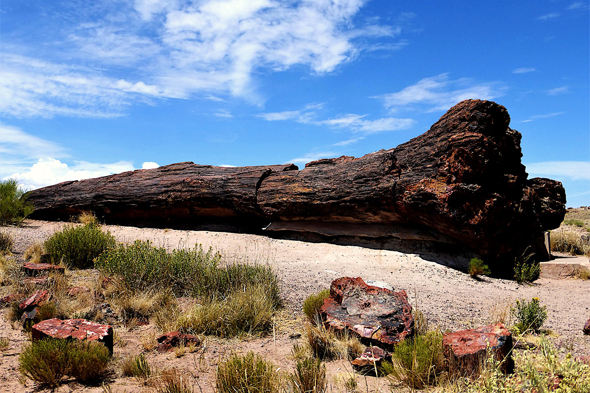
| Opening image | Large petrified trunk | The recognisable shape of wood preserved in stone |
| Blue Mesa badlands | Blue, grey and lavender hills | Fine mineral layers exposed by erosion |
| Petrified wood cross-section | Colourful mineral interior | Quartz and trace minerals replacing the original wood |
| Historic Route 66 | Rusting early automobile | The human journey through the landscape |
| Painted Desert panorama | Red badlands and distant mesas | The scale and open horizon of northern Arizona |
| Log among banded hills | Petrified wood within its setting | The relationship between fossil material and eroding sediment |
| Blue Mesa overlook | Badlands and scattered wood | Patterns that become visible from a higher viewpoint |
| Colourful badland bands | Blue, ochre and grey layers with scattered wood | How leaving out the sky turns geology into pattern |
| Petrified wood fragments | Broken logs on pale ground | The contrast between red stone and light bentonite clay |
A closer look at the photographs
The strongest way to understand Petrified Forest is to move between scales. A wide view explains the desert; a close view explains the wood. The photographs become more interesting when neither is asked to do the entire job.
Blue Mesa: a landscape of folded colour
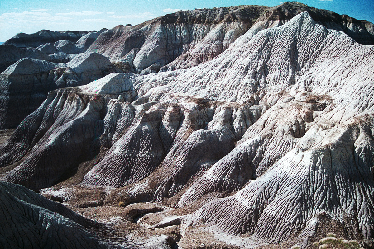
Blue Mesa is one of the park’s most recognisable subjects because its colour palette departs from the expected red desert. Rounded hills rise and fold into one another, their surfaces cut by rain and wind into ridges, gullies and narrow channels. From a distance the land can look smooth; a closer view reveals how fragile and finely textured it is.
This photograph works through repetition. No single hill dominates. Dark caps, pale slopes and shadowed channels move the eye across the frame. It also shows why the park is not only about petrified logs. The surrounding geology supplies the scale, colour and sense of deep time that give the wood its meaning.
The mineral interior of a tree
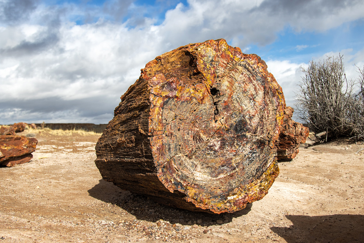
The circular face is immediately legible as a tree, but its colour belongs to stone. The preserved pattern does not mean that every visible line should be read exactly like the annual rings of a freshly cut trunk. Mineral replacement, fractures and later weathering all shape the surface we see now.
Silica is the main material in much of the petrified wood, often in the form of quartz. Trace minerals contribute colour: iron can produce red, orange and yellow tones, while manganese and other elements can create darker colours. A close photograph makes that mineral variation visible without losing the original form of the tree.
Route 66 through the grassland
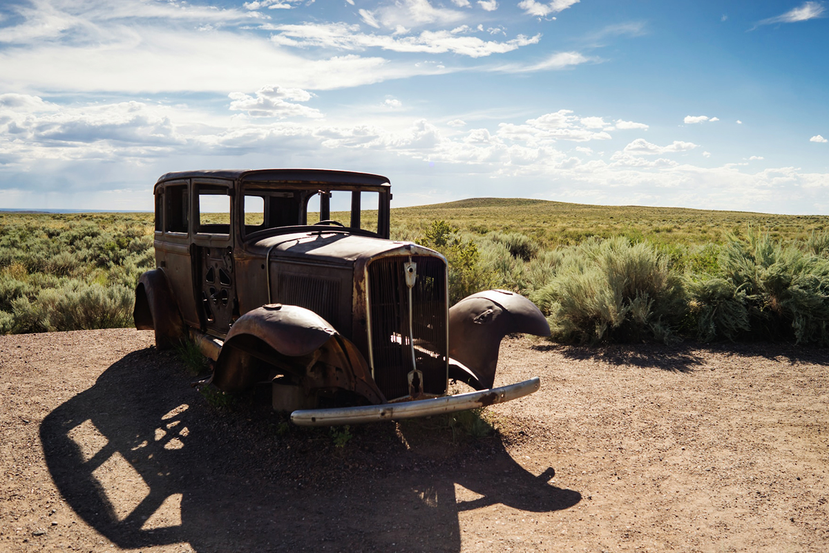
This may be the least expected image in a collection devoted to petrified wood, but it belongs to the park’s story. Petrified Forest is the only national park site containing a section of the historic Route 66 alignment. The road itself no longer carries traffic here. A line of telephone poles and the weathered car mark its passage through the grassland.
The photograph is powerful because the vehicle looks both temporary and enduring. The forest was transformed over more than 200 million years; Route 66 belongs to the recent past. Yet the automobile is already being absorbed visually into the same dry, open landscape.
The red expanse of the Painted Desert
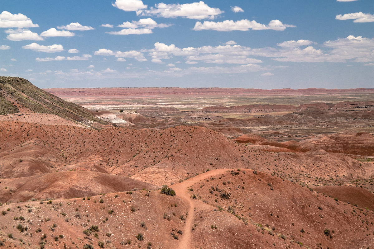
The Painted Desert extends far beyond the park, but Petrified Forest protects a particularly accessible section of it. In the northern overlooks, red and orange hills fall away toward distant mesas. The sky often occupies half the composition because the horizon is so low and open.
This view is not built around spectacular foreground drama. Its strength is distance. A path or drainage line leads through the lower terrain while atmospheric haze separates the successive layers. On a clear day the landscape can appear hard and dry; after moisture, the red sediment becomes deeper and more saturated.
Petrified wood within the badlands
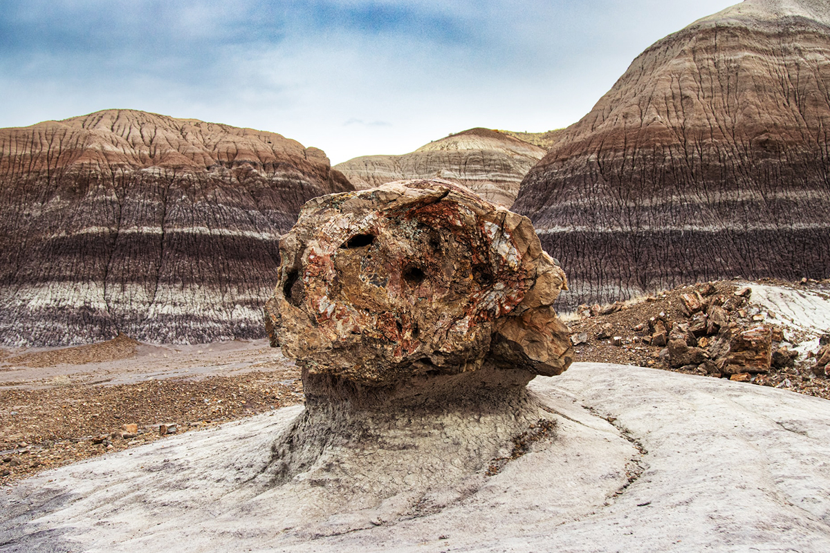
The log in this photograph acts as a bridge between the two central subjects of the park. Its rounded cross-section and dark bark-like exterior are clearly visible, while striped hills rise behind it. The scene explains why fossil wood lies on the surface today. Erosion removes the softer rock around the more resistant quartz-rich logs, leaving them exposed.
The process is still continuing. The landscape is not a finished museum display. Rain, temperature changes and gravity gradually move sediment and break exposed logs into sections. A photograph records one temporary arrangement in a landscape that continues to change.
Looking across Blue Mesa
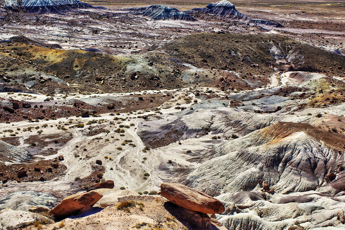
An elevated view shows relationships that disappear at ground level. Pale channels weave between darker slopes, scattered sections of wood introduce warm colour and the larger forms of the badlands repeat toward the horizon.
Blue Mesa can therefore support two very different kinds of photograph. From an overlook, the landscape becomes pattern and scale. On the trail below, the hills become walls and the petrified wood becomes a foreground subject. Neither view is complete on its own.
When colour becomes the subject
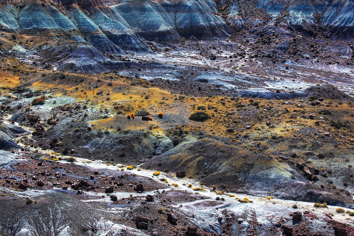
Leaving the sky out changes what a photograph is about. Without a horizon or a familiar landmark, the surface begins to resemble an abstract painting. Yellow deposits collect along the middle bench, dark blue slopes provide weight, pale channels trace the path of runoff, and dark fragments of petrified wood are scattered across the whole scene.
This is where a moderate telephoto lens can be more useful than an ultra-wide lens. Compression simplifies the scene and lets the photographer select one relationship among many. The result is less descriptive than a panorama but more attentive to the park’s unusual colour.
Logs scattered across pale ground
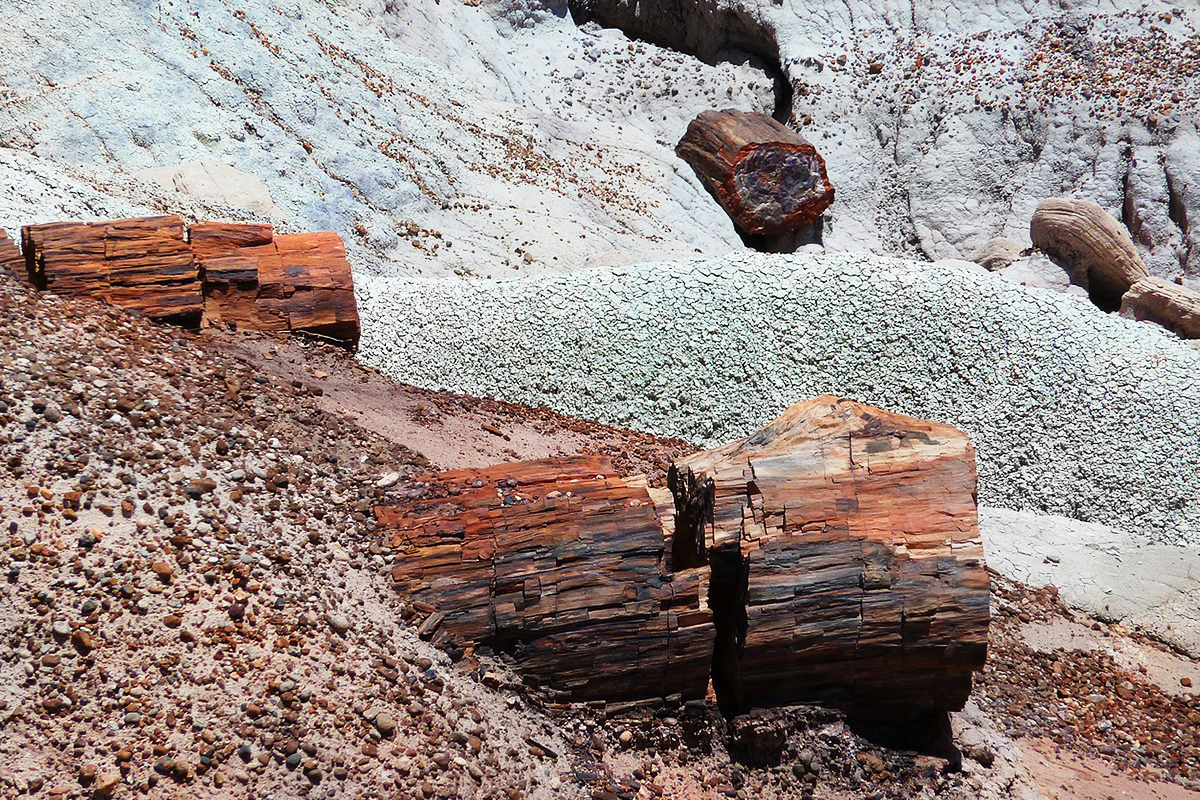
Several fragments sit at different distances, allowing the eye to move into the frame. The warm red-brown stone contrasts with the pale clay, while the rounded shapes retain the memory of trunks. It is easy to understand why early visitors wanted to take pieces home — and why removal is now prohibited.
The park protects a finite resource. Even a small fragment matters when hundreds of thousands of people visit over time. The only responsible souvenir from these scenes is a photograph; petrified wood sold legally outside the park comes from private land and not from protected park deposits.
What is Petrified Forest National Park?
Petrified Forest National Park lies in northeastern Arizona, between Interstate 40 and Highway 180, roughly 50 miles west of the New Mexico border. The park’s main road runs 28 miles, or 45 kilometres, from the north entrance to the south entrance. Driving straight through takes about an hour, but most visitors need at least two to three hours once overlooks and short walks are included.
The park protects much more than fossil wood. It contains colourful badlands, short-grass prairie, archaeological sites, petroglyphs, historic buildings, a former Route 66 alignment and a large wilderness area. The entire park lies within the broader Painted Desert.
| Quick fact | Current information |
|---|---|
| State | Arizona, United States |
| North entrance | Exit 311 from Interstate 40 |
| South entrance | Highway 180, east of Holbrook |
| Main park road | 28 miles / 45 kilometres |
| Drive without stops | About one hour |
| Typical visit | Two to three hours; half a day is better for photography |
| Park hours | Generally 8:00 a.m.–5:00 p.m. Mountain Standard Time |
| Timed entry | Not required |
| Standard private-vehicle fee | $25, valid for seven days |
| Main landscapes | Painted Desert, Blue Mesa, grassland and petrified-wood deposits |
| Highest concentrations of wood | Primarily in the southern part of the park |
| Nearest town with broad services | Holbrook, Arizona |
The official National Park Service page should be checked shortly before arrival, because winter weather, road safety, construction and special events can affect access.
How did the wood become stone?
More than 200 million years ago, during the Late Triassic Period, this region was not the high, dry Arizona landscape seen today. River systems crossed a much wetter environment. Trees fell and were carried into channels, where some accumulated in log jams and were buried under sediment and debris.
Rapid burial reduced exposure to oxygen and slowed ordinary decay. Water moving through volcanic ash and sediment carried dissolved silica into the porous wood. Over hundreds and thousands of years, minerals crystallised within the cellular structure as the organic material broke down. The tree’s form was preserved while its substance changed.
The result is not wood coated with stone. Much of the original organic material has been replaced by quartz. In larger cracks and cavities, crystals such as clear quartz, amethyst, citrine and smoky quartz can form. Iron, manganese and other trace elements contribute the red, yellow, brown, purple and dark colours visible in broken surfaces.
Why do the logs look cut into sections?
Many trunks are broken into pieces with surprisingly flat faces. They were not neatly sawn by people. Quartz-rich petrified wood is hard but brittle. As the surrounding sediment eroded and stopped supporting a log evenly, stress and natural fractures caused it to break into shorter sections.
Why are the badlands so colourful?
Much of the visible landscape belongs to the Chinle Formation, deposited by ancient rivers during the Late Triassic. The colour records mineral composition and the chemical conditions within ancient sediment and soils. Iron exposed to oxygen can create red and orange tones. Low-oxygen conditions can produce greenish, bluish and grey layers. Erosion then reveals those bands as slopes, buttes and gullies.
Blue Mesa is especially known for blue, purple, grey and green mudstone. The northern Painted Desert overlooks are dominated by warmer reds. The visual difference is one reason a drive through the entire park feels like more than a journey between two gates.
The main photographic stops from north to south
The easiest way to understand the park is as a linear journey. Visitors can enter at either end, but the north entrance is convenient for westbound travellers on Interstate 40, while the south entrance works well for eastbound travellers approaching through Holbrook.
Painted Desert overlooks
The northern section begins with broad views across the red part of the Painted Desert. Overlooks make it possible to study changes in foreground, horizon and light without a long hike. Tawa Point and Kachina Point are linked by the one-mile round-trip Painted Desert Rim Trail, giving more varied compositions than photographing only from a parking area.
Painted Desert Inn
At Kachina Point, the Painted Desert Inn is both a historic building and an overlook. The Pueblo Revival structure is now a National Historic Landmark and museum rather than a functioning hotel. Its walls, windows and terraces provide human scale against the enormous desert.
Historic Route 66 alignment
The rusting car and line of telephone poles mark where Route 66 once crossed the park. A wide composition places the vehicle in the grassland; a lower or tighter view concentrates on texture, shadow and decay. This is one of the few places where a cultural object, rather than geology, becomes the obvious subject.
Puerco Pueblo and Newspaper Rock
Puerco Pueblo preserves the remains of a large ancestral Puebloan community. The paved loop is approximately 0.3 mile, or 0.5 kilometre. Nearby, Newspaper Rock is viewed from an overlook and contains more than 650 petroglyphs, some up to about 2,000 years old.
These are cultural sites, not decorative foregrounds. Visitors should not climb on walls or boulders, touch petroglyphs or move any object. A longer lens is useful at Newspaper Rock because access is intentionally kept at a distance.
Blue Mesa
Blue Mesa offers both a 3.5-mile scenic loop road and a one-mile walking trail. The road has overlooks across the blue and purple badlands; the trail descends among them. Its first grade is steep, and the return climb can feel more demanding in heat or wind than the short distance suggests.
For photography, the overlook and trail solve different problems. The overlook reveals patterns. The trail gives depth, foreground and close relationships between wood and sediment.
Agate Bridge and Jasper Forest
Agate Bridge is a petrified log approximately 110 feet, or 34 metres, long spanning a gully. A concrete support added in the early 20th century remains beneath it. The support changes the visual experience but is also part of the site’s conservation history.
Jasper Forest provides a panoramic view across one of the park’s major concentrations of petrified wood. The pieces are smaller in the frame than at Giant Logs or Crystal Forest, so a longer focal length helps isolate colour and arrangement within the broader valley.
Crystal Forest
The paved Crystal Forest loop is 0.75 mile, or 1.2 kilometres. It is one of the most efficient walks for seeing abundant petrified wood at close range. Sun can create bright reflections on quartz-rich surfaces, while overcast conditions make colour easier to record without harsh contrast.
Rainbow Forest, Giant Logs and Long Logs
Near the south entrance, Rainbow Forest Museum introduces the park’s fossils and provides access to several trails. Giant Logs is a 0.4-mile loop containing some of the park’s largest and most colourful trunks. Long Logs is a 1.6-mile loop through another major concentration of wood.
The opening photograph of this article represents the kind of scale found in the southern deposits: a trunk large enough to dominate a frame but still surrounded by open prairie and sky.
Best photo spots in Petrified Forest National Park
| Location | Best subject | Useful lens or approach | Time needed |
|---|---|---|---|
| Tawa or Kachina Point | Red Painted Desert panorama | Wide to normal lens; include sky only when it adds structure | 15–30 min |
| Painted Desert Rim Trail | Changing rim views and juniper foregrounds | Walk rather than relying on one overlook | 30–60 min |
| Route 66 alignment | Rusting car, poles and grassland | Normal or moderate wide lens; use low side light | 15–20 min |
| Puerco Pueblo | Architecture and cultural landscape | Normal lens; photograph without climbing or touching | 20–30 min |
| Newspaper Rock | Petroglyphs from a protected overlook | Telephoto lens | 15–20 min |
| Blue Mesa overlooks | Layered blue and purple badlands | Normal to telephoto for patterns | 30–45 min |
| Blue Mesa Trail | Immersive badlands and petrified wood | Wide to normal lens; prepare for a steep return | 45–75 min |
| Jasper Forest | Petrified wood across a broad valley | Moderate telephoto to isolate groups of logs | 15–30 min |
| Crystal Forest | Close wood details and trail landscapes | Normal lens and close-up capability | 30–60 min |
| Giant Logs | Massive trunks and mineral colour | Wide-to-normal lens; include people only for scale | 30–45 min |
The best light for photography
Petrified Forest is often described as a sunrise-and-sunset location, but access hours change the practical answer. The park is generally open from 8:00 a.m. to 5:00 p.m. Arizona remains on Mountain Standard Time throughout the year, and gates close after park hours. Do not plan a conventional pre-dawn arrival or an after-sunset session unless an authorised activity specifically allows it.
In winter, low sun can remain available during normal hours. In summer, sunrise occurs well before opening and sunset well after closing, so the best permitted light is usually early after the gates open or late before visitors must leave. The angle of the sun matters more than the label “golden hour”.
Clear sun
Strong sun intensifies shadows and can make pale sediment difficult to expose beside dark petrified wood. It works well when the goal is structure: the edge of a log, the ridges of a badland hill or the shadow of the Route 66 car.
Overcast light
Thin cloud reduces contrast and reveals colour in the wood. It is particularly useful for close views where direct reflections from quartz would otherwise distract from mineral patterns.
After rain
Moisture can deepen the colour of both sediment and petrified wood, but rain changes safety conditions. Bentonite-rich surfaces become extremely slippery and sticky. Unpaved routes may be unsuitable, and flash flooding can affect washes and roads. A stronger photograph is not worth ignoring a closure or crossing flooded ground.
Wind and atmospheric conditions
Late winter and spring can be very windy, with official park information noting regular winds around 40 mph and occasional stronger gusts. A tripod does not automatically solve that problem; a lowered centre column, compact stance and faster shutter speed may be safer and more effective.
Camera equipment I would choose
Because I have not photographed the park in person, I would not present exact camera settings as field-tested formulas. The landscape itself suggests a practical kit:
- A normal zoom. A 24–70 mm equivalent covers most overlooks, trail scenes and large logs without exaggerating perspective.
- A moderate telephoto. A 70–200 mm equivalent isolates layers at Blue Mesa, petroglyphs at Newspaper Rock and sections of the Painted Desert.
- Close-focus capability. A macro lens is optional. A normal zoom that focuses closely is enough for many mineral details.
- Lens hood and cleaning cloth. Windblown dust and bright side light are more likely problems than lack of equipment.
- Spare battery and power bank. The park is linear, services are limited and temperature extremes can reduce battery performance.
- Water before accessories. In an exposed landscape with little shade, water, sun protection and appropriate footwear belong ahead of extra lenses.
A circular polariser can reduce some reflections and deepen colour, but it should be used carefully with wide skies because the polarising effect can become uneven. It can also remove the small highlights that make quartz surfaces look crystalline.
Short trails for photographs
| Trail | Distance | Main photographic reason | Important consideration |
|---|---|---|---|
| Tawa Trail | 1.2 mi / 1.9 km one way | Grassland and Painted Desert transition | Requires a return walk or transport plan |
| Painted Desert Rim | 1 mi / 1.6 km round trip | Multiple northern rim viewpoints | Unpaved with uneven grades |
| Puerco Pueblo | 0.3 mi / 0.5 km loop | Pueblo remains and petroglyph context | Do not touch or climb on cultural resources |
| Blue Mesa | 1 mi / 1.6 km loop | Immersive blue badlands and wood | Steep grade at the beginning and end |
| Crystal Forest | 0.75 mi / 1.2 km loop | Abundant colourful petrified wood | Exposed, with little shade |
| Giant Logs | 0.4 mi / 0.6 km loop | Some of the largest logs in the park | Stairs and steep sections |
| Long Logs | 1.6 mi / 2.5 km loop | Large concentration of petrified wood | Rougher surface beyond the first section |
| Agate House | 2 mi / 3.2 km round trip | Cultural landscape and petrified-wood pueblo | Stay at least 15 feet from the structure under current safety rules |
Most developed trails are paved or partly accessible, but “paved” does not mean flat. Grades, cross slopes, stairs and weather can affect access. The official trail descriptions provide detailed measurements for visitors using wheelchairs, mobility equipment or strollers.
How much time do you need?
One hour
Driving the full 28-mile road without stops already takes about an hour, so a one-hour visit should focus on one end. In the north, choose several Painted Desert overlooks and the Route 66 stop. In the south, choose Rainbow Forest Museum, Giant Logs or Crystal Forest. Trying to include both ends will leave almost no time outside the car.
Two to three hours
This is the typical visit described by the National Park Service. Drive through the park, stop at selected Painted Desert overlooks, photograph Route 66, take the Blue Mesa loop road and choose one short trail such as Crystal Forest or Giant Logs.
Half a day
A half-day allows the park to feel like a place rather than a sequence of parking areas. Add the Blue Mesa Trail, Puerco Pueblo, Newspaper Rock and a second petrified-wood walk. Build in time for wind, changing light and the distance between stops.
A full day
A full day is the strongest choice for photography within normal park hours. Enter when the gates open, move slowly through the northern overlooks, photograph cultural sites around midday, then concentrate on Blue Mesa and the southern wood deposits later in the afternoon. Confirm the required exit time and work backward from it.
Location, entrances and driving directions
Petrified Forest National Park has two entrances. The north entrance connects directly to Interstate 40 at Exit 311. The south entrance connects to Highway 180, approximately 19 miles east of Holbrook. There is no public transportation to or within the park, so most visitors need a private or rental vehicle.
Westbound on Interstate 40
Use Exit 311, enter at the north gate and drive south through the park. After leaving at Highway 180, the road returns to Interstate 40 through Holbrook.
Eastbound on Interstate 40
Leave Interstate 40 at Exit 285 in Holbrook, follow Highway 180 to the south entrance and drive north through the park, exiting at Interstate 40.
From Albuquerque
The official route is approximately 204 miles west on Interstate 40 to Exit 311. The north entrance is the natural starting point.
From Flagstaff and Phoenix
From Flagstaff, travel east on Interstate 40. From the north and west side of the Phoenix area, the common route follows Interstate 17 north to Flagstaff and then Interstate 40 east. The National Park Service lists this Phoenix route at approximately 259 miles.
Download the official map before arrival. Mobile service may be available in parts of the park, but it should not be the only navigation plan.
Current opening hours, fees and services
At the time of this update, the park is generally open from 8:00 a.m. to 5:00 p.m. Mountain Standard Time and is closed on Thanksgiving and Christmas. Arizona does not observe daylight saving time in the same way as most of the United States, so the time difference with neighbouring New Mexico changes seasonally.
| Item | Current information |
|---|---|
| Private vehicle | $25, valid for seven days |
| Motorcycle | $20, valid for seven days |
| Individual on foot or bicycle | $15 for age 16 and older, valid for seven days |
| Petrified Forest annual pass | $45 |
| Payment | Cashless; debit or credit card |
| Timed reservation | Not required |
| Camping | No developed campground; wilderness camping requires a free permit |
| Fuel and food | Limited services near the north entrance; carry water and do not depend on late food availability |
| Restrooms | Available at principal visitor facilities and selected sites |
Current construction note, August 2026: the National Park Service lists the Painted Desert Visitor Center building as closed for construction. The surrounding community complex remains accessible, with services including the gift shop, gas station, restaurant, restrooms, picnic pavilion and Tawa Trail access. Painted Desert Inn is serving as the northern visitor-information location, while Rainbow Forest Museum operates near the south entrance. Check the current visitor-centre page, because this arrangement will eventually change.
Weather and the best season to visit
Petrified Forest sits at elevation in an exposed high-desert and grassland environment. It is not permanently hot. Conditions can move from strong sun to wind, snow or thunderstorms depending on the season.
Spring
Spring can bring comfortable temperatures and wildflowers, particularly after winter moisture. It is also one of the windiest periods. Protect equipment from dust and secure loose items before opening a car door at an overlook.
Summer
Summer brings heat, intense sun and very limited shade. The official Arizona monsoon season runs from June 15 through September 30, with thunderstorms becoming more common later in the day. Lightning and flash floods are serious hazards. A metal-roofed shade structure is not a safe refuge from lightning; return to a vehicle when storms approach.
Autumn
Autumn often offers more moderate temperatures and clearer walking conditions. Days shorten, which can bring lower-angle light closer to normal opening hours. Weather still changes quickly, and wind remains possible.
Winter
Snow and rain can occur from October through March. Snow often melts quickly, but roads may open late when conditions are unsafe. Moisture can deepen the colour of the Painted Desert, while cold wind makes the temperature feel much lower. Check current park conditions before driving.
Photography rules and protecting the park
Ordinary visitor photography is straightforward. Under the National Park Service guidance introduced after the 2025 EXPLORE Act, a permit is generally not required for groups of eight or fewer people when the activity takes place in areas open to the public, uses only hand-carried equipment, does not require exclusive use, does not damage resources or disrupt visitors and does not create additional administrative costs.
Larger or more complex productions may require a permit, application fee and location charges. The distinction is based on impact and logistics rather than simply whether the photographer earns money. Anyone planning a crew, controlled set, exclusive access or substantial equipment should read the official filming and photography rules before travelling.
The more important everyday rules are simpler:
- Do not remove petrified wood, rocks, plants, pottery fragments, Route 66 debris or any other natural or cultural object.
- Stay on designated trails in developed hiking areas and respect every closure sign.
- Do not climb on archaeological walls or touch petroglyphs.
- Park only in designated spaces or fully outside the road’s white line where stopping is legally permitted.
- Keep wildlife at a distance and never use food to create a photograph.
- Carry out every piece of waste.
- Leave before the park closes rather than planning a final photograph beyond authorised hours.
The human landscape is as important as the fossils
The petrified wood is more than 200 million years old, but the park is not a place without human history. People have lived, travelled and worked through this landscape for thousands of years. Hunter-gatherers found and used petrified wood more than 13,000 years ago. Ancestral Puebloan communities built homes and left petroglyphs. Modern Indigenous nations retain deep cultural connections to the region.
Later layers include Spanish and American exploration, the 35th-parallel survey routes, the Beale wagon road and camel experiment, ranching, the railway, Route 66 and the Civilian Conservation Corps. Petrified Forest became a national monument in 1906 and a national park in 1962.
That history changes the way I read the photographs. The old car is not an interruption in a geological article. Puerco Pueblo is not a side attraction between viewpoints. The park contains different measures of time — Triassic rivers, centuries of human settlement, a road remembered within living memory — and they occupy the same landscape.
Petrified Forest National Park on Instagram
The two Instagram posts below extend the visual record beyond the photographs in the main gallery. I have kept them together here rather than turning the article into a generic list of hashtags.
For more American landscapes, see my photos of Bryce Canyon National Park, photos of Mount Rushmore and photos of Acadia National Park.
Frequently asked questions
Is Petrified Forest National Park worth visiting?
Yes, especially for geology, landscape photography, archaeology and Route 66 history. It is not a dense standing forest, so visitors expecting stone trees rising vertically may initially misunderstand the place. Its strength is the combination of open desert, coloured badlands and petrified logs lying where erosion has exposed them.
How long does it take to drive through the park?
The main road is 28 miles, or 45 kilometres. Driving without stopping takes about one hour. Most visitors spend two to three hours, while photographers and hikers benefit from half a day or a full day.
What are the best places for photographs?
The Painted Desert overlooks, Route 66 alignment, Blue Mesa, Jasper Forest, Crystal Forest and Giant Logs provide the broadest visual variety. Newspaper Rock is important for petroglyphs, but it is viewed from a protected overlook and benefits from a telephoto lens.
Can I visit both the Painted Desert and Petrified Forest?
Yes. The whole national park lies within the larger Painted Desert. The red Painted Desert views are concentrated in the north, Blue Mesa occupies the central portion and many of the largest petrified-wood deposits are toward the south.
Can I take petrified wood home?
No. Removing petrified wood or any other natural or cultural resource from the park is prohibited by federal law. Legal souvenir wood sold in shops outside the park comes from private land.
Is the petrified wood real wood?
It began as wood, but most of its organic material was replaced by minerals — principally silica that crystallised as quartz. The cellular structure and shape of the tree were preserved during that replacement process.
Do I need a timed reservation?
No timed-entry reservation is currently required. Every visitor still needs a valid entrance pass, and the park road is accessible only during posted hours.
Can I enter for sunrise or stay after sunset?
Not under ordinary daily access when sunrise or sunset falls outside park hours. The park is generally open from 8:00 a.m. to 5:00 p.m. MST, and gates close. Plan low-angle-light photography within the authorised schedule and check for official programmes that may provide different access.
Are tripods allowed?
Hand-carried photography equipment, including a normal tripod, generally fits ordinary visitor photography when it does not block access, damage resources or require exclusive use. Larger productions or activities creating additional impact may require a permit.
Which entrance should I use?
Westbound Interstate 40 travellers usually use Exit 311 and enter from the north. Eastbound travellers can leave Interstate 40 in Holbrook, follow Highway 180 and enter from the south. Driving through in one direction avoids retracing the entire park road.
Is there food, fuel or lodging inside the park?
Limited food and fuel are available near the north entrance, with snacks and basic services at selected facilities. There is no hotel and no developed campground inside the park. Holbrook is the nearest town with a broader range of lodging and services.
Can children and pets use the trails?
Many short trails work well for families, although grades, heat and exposure should be considered. Pets are allowed on developed trails and in most outdoor areas where visitors may go, but not inside buildings. They must remain on a leash no longer than six feet, and owners must clean up after them.
Official planning resources
For current access rather than evergreen assumptions, use the official National Park Service pages:
- Petrified Forest National Park homepage
- Hours and seasons
- Fees and passes
- Park maps
- Trails and accessibility details
- Current conditions and alerts
Final thoughts
I came to Petrified Forest through images, and that is still the most honest way for me to end this guide. I have not stood on the Blue Mesa Trail or watched the light move across the Painted Desert. What held my attention was the tension inside the photographs: trees that look familiar but are made of quartz, hills that appear painted but are records of ancient sediment, and a modern road already fading into history.
The photographs also corrected my first idea of the park. Petrified Forest is not one subject repeated across a desert. It is a sequence: red overlooks, grassland, petroglyphs, blue badlands, scattered logs and historic Route 66. The complete picture appears only when those pieces are allowed to remain different.
That is why I would approach the park slowly, even on a short visit. Begin with a wide view, move closer to the wood, and make room for the cultural landscape between them. Take the photographs, leave every fragment where it lies and let the park continue changing on its own timescale.